|
Storm Spotter's Field Guide
CONTENTS:
The Alachua County Area Storm Spotter's Field Guide is a project that
I've been wanting to put together for many, many years, now. I've always talked
about it but never really had enough to actually fill it with meat. I've
talked about it and talked about it with friends. I've got emails going back
to 1997, in fact. Over the years, we've slowly been able to accumulate enough
such that now I think this is finally able to become a reality.
The NOAA/NWS Storm Spotter Field Guide series are wonderful reference
materials. However, while beginning to get kind of outdated, they also tend to
use examples of storm features and events which occur only out in the
Midwest, and that's always bothered me. In the Midwest, the air is much drier.
As a result, the storms are different in appearance out there than they are
here in much wetter Florida. In the Midwest, the storm bases are much
higher, and so, you can see much farther underneath them. There is less
accessory cloudage such as scud, and thus, this doesn't get in the way (as
much). And so, you can see much more of the storm's sides and features in the
Midwest. You're able to better gauge where you are in relation to the storm,
and what is going on within a storm. In Florida, most of the severe storms are
high-precipitation (HP) storms.
This has been my biggest worry with Florida storms. While we may never see
tornadoes which match the unheard of powers seen in the Midwest, I consider
Florida storms to potentially be sometimes more dangerous because with the
storm bases being so low, and with there being so much scud and other lower
level clouds in the way, it is much more difficult for the spotter (much less
anyone else) to see anything at all, and thus what is going on. As a result,
there are plenty of past examples where people here tend to get hit by surprise
more often. The ONLY friend becomes NWS RADAR and the NOAA Weather Radio to
clue you in that something could be occuring near you. Spotters are a great
asset, but we cannot see everything - and that goes especially at night.
But of what we CAN see, I am putting together this local area Storm Spotter's
Field Guide to help spotters and others to better interpret what they are
seeing out there in FLORIDA climate. This will be a compendium put together
of photos and videos gathered by myself and by others.
If you have a photo or a video of a severe weather related feature or event
occuring here in Alachua County and you think it shows something which might
be helpful to spotters, then please feel free to submit it to us. We will
always give proper credit to the respective authors who submit their
materials to us.
I plan to eventually also add things we've seen which demonstrate examples of
look-a-likes and "things that are NOT". For, as much as a spotter needs to
see real examples of the actual stuff, they also should be able to see
real-life examples of the things that can fool. And in my life's
experience as a learning spotter over the years, I've been awed and fooled by
many things which looked like they could be something but actually weren't.
Sometimes this takes contacting your local NWSFO and communicating with them
to find out current conditions noted in your area which could help you to
determine whether something you see might be anything to worry about or not.
Never be afraid to check!
With that, let's get this started...
Severe Wind Storm -- A Microburst? Or A Low-grade Tornado?
Date/Time: July 20, 2000, 16:41 Hrs EDT
On Thursday, July 20th, 2000, many areas in Gainesville were hit with strong
winds from a severe thunderstorm, including here at my own home here in
Whitney Mobile Home Park. Was it a microburst situation? or was it actually
a tornado passing over my home? There are clues in the actual video which
tend to make me wonder if it wasn't actually a low-grade tornado.
[ Description / More About It ] (with lots more photos)
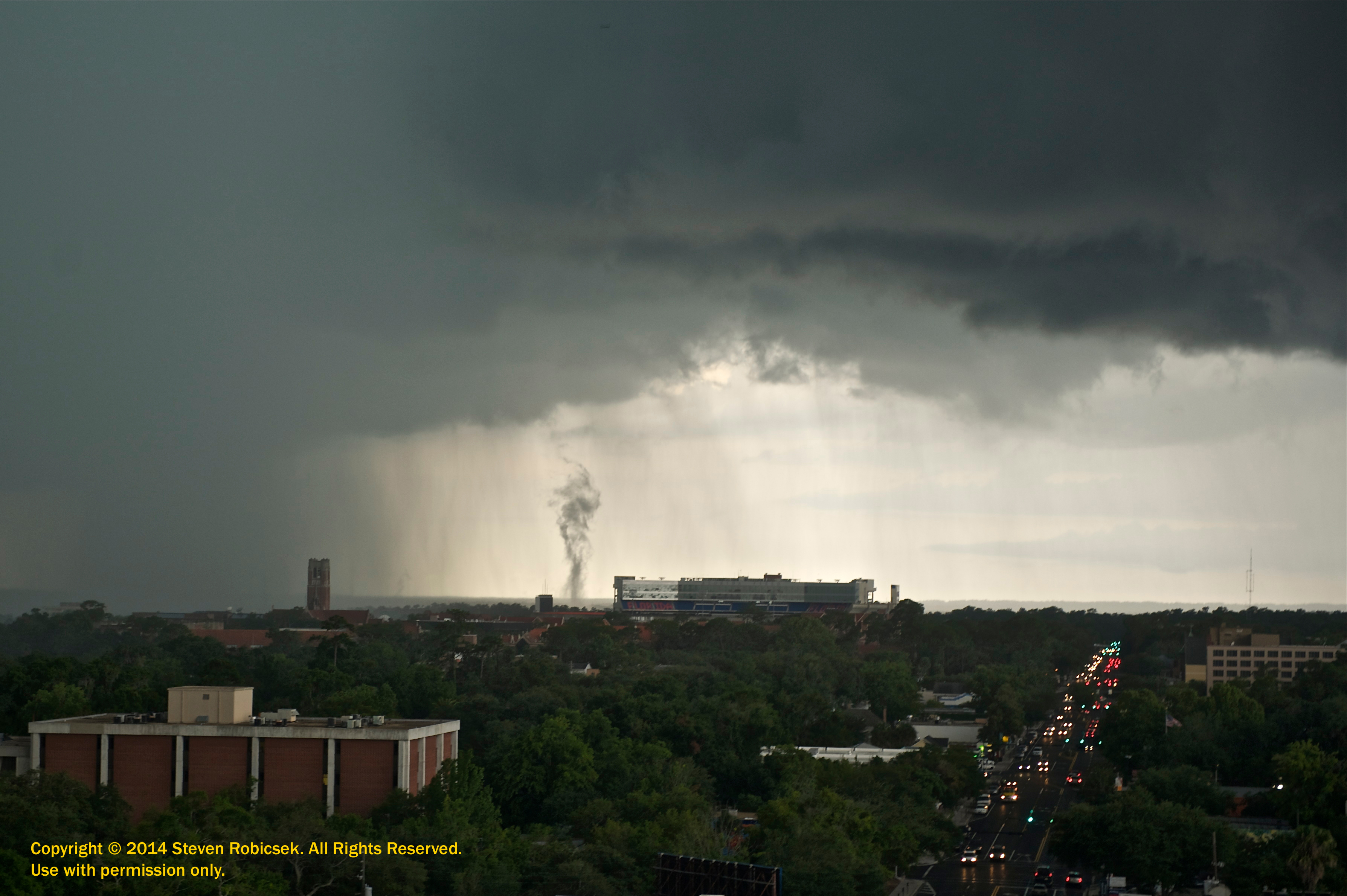
Date/Time: June 29, 2010, 17:44 Hrs EDT
Photo by Dr. Steven A Robicsek, MD, PhD. Taken June 29, 2010 at 5:44pm, from
atop the Seagle Building on University Avenue, looking west at the Ben Hill
Griffith Stadium. Unless someone else comes forward, this could well be the first-ever photograph of a gustnado ever taken within Alachua County.
[ Description / More About It ]
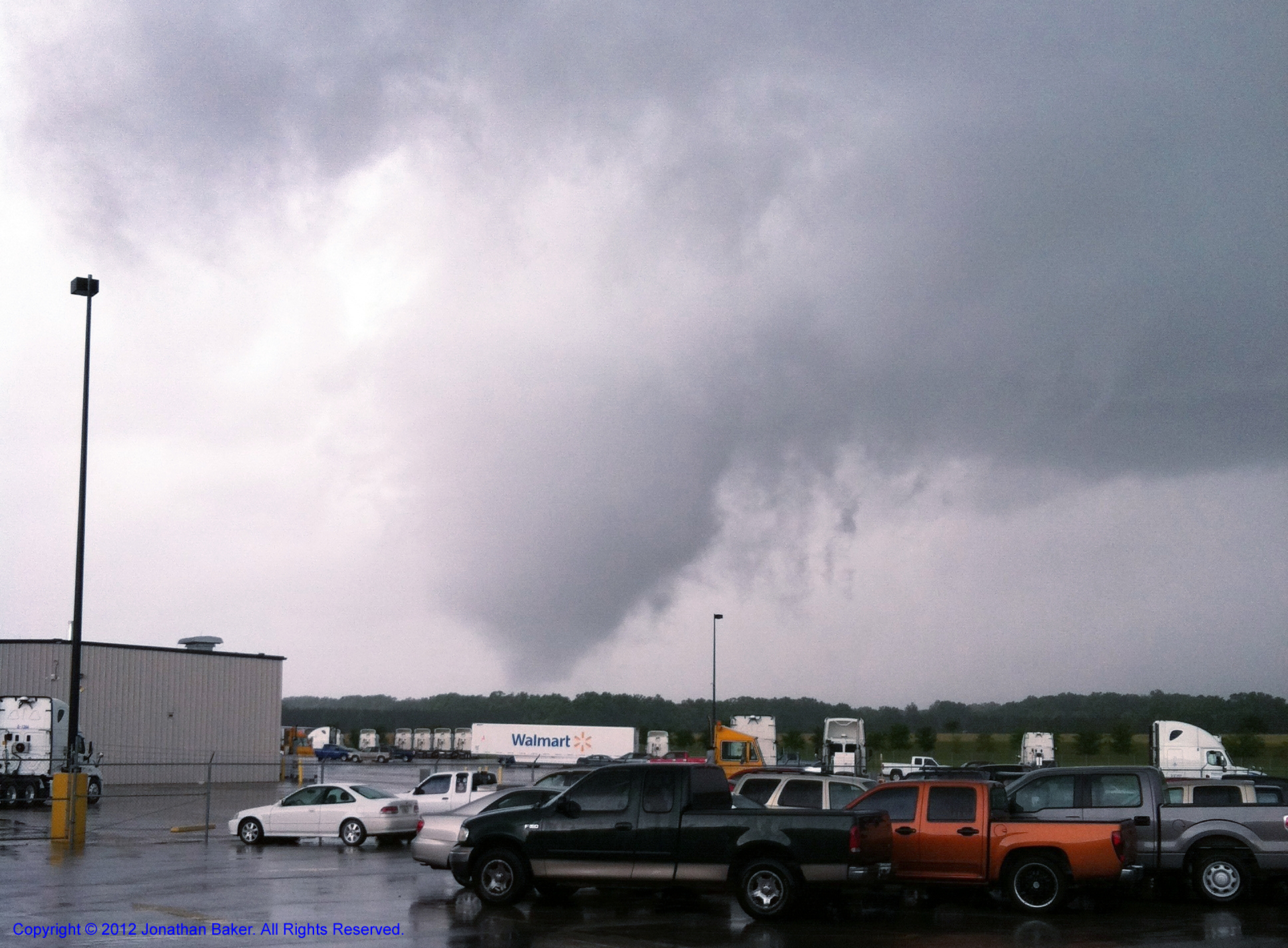
Alachua EF-0 Tornado - 03/24/2012
Date/Time: March 24, 2012 - 14:50 Hrs EDT
Tornadoes do occur within Alachua County. However, actually nabbing a photo or video of one has up until now proven to be very difficult. We've been researching tornado photography within Alachua County for a while and we've not been able to come up with anything up until now. This may well be the first-ever photograph of a tornado ever taken within the county. Congratulations to John for the shot.
Jonathan was also able to take a video of the tornado. We will upload that here as soon as we obtain it.
Our thanks to Jonathan for his permission to place them here for people to use to learn.
[ Description / More About It ]
Date/Time: Mid-2004 (Exact Date/Time Unknown)
Video of a cool, mean-looking approaching squall line that was very windy
and showed some very obvious green - sometimes indicative of hail. Exact
date and time of occurance is unknown, except that it occurred sometime in
Mid-2004. Courtesy Jim Carr / KC4MHH.
Multicell Thunderstorm & Associated Gust Front
Date/Time: July 08, 2008, 18:44 Hrs EDT
While in front of the Wal-Mart on Archer Road in Gainesville, FL, I took
time out to video a large thunderstorm to the southwest.
[ Description / More About It ]
North Central Florida Cross-County Hail Event
Date/Time: May 14, 2000, 17:12 Hrs EDT
On Sunday, May 14th, 2000, a weak cold front and two stronger sea breeze fronts
collided across northern Florida to create a severe thunderstorm which produced
hail that ranged in size from 1/4-inch to 3/4-inch (in Gilchrist county), and
from 3/4-inch to 3-inches (in northwest Alachua county). The hail was
accompanied with strong winds and very heavy rains which lasted up to 9-minutes
at Whitney Mobile Home Park.
Multiple methods of photo-documentation by various sources across Alachua
County.
[ Description / More About It ]
Monteocha Hail Event - March 01, 2003
Date/Time: March 01, 2003
Hail event that occurred in Monteocha, Alachua County, FL on the property of Al
Pinson. Surprising, spectacular and even eerie photography taken by
Michael Robinett / W4UAV.
[ Description / More About It ]
Western Alachua County Hail Event - March 14, 2012
Date/Time: March 14, 2012, 19:00 Hrs EDT
Hail event that occurred in various places in western and southwestern Alachua
County, FL, mostly along I-75 from CR-222 (NW 39th Ave) to Newberry Road and
Archer Road. The storms came from offshore of Jacksonville heading southwest
and in traversing our area even took out power in patches west of I-75. A
number of storm spotters reported hail events with hail of varying sizes from
graupel (pea-sized or less) to up to quarter-sized (1/25 inches). The hail
even caused enough confusion to cause some minor accidents along Newberry Road
in the area in front of the Oaks Mall.
[ Description / More About It ]
Location: Gainesville, FL
I was at my desk in my bedroom during a thunderstorm with my window blinds
closed when out of the corner of my eye, through cracks between the leaves
of the blinds next to me I saw a VERY bright repeated flash, followed almost
instantly by an extremely loud thundercrash. I ducked by instinct and then
opened the blinds and sat back down and tried to remember where the flash
had occured through the blinds to try to gauge where the stike had occured
exactly. I was able to narrrow it down to a tree in a resident's yard one
street down from me. After the storm was over, I went over to the resident's
house and got permission to videotape the strike damage to the tree to document
it for educational purposes.
Location: Gainesville, FL
Yet another awesome photo taken by local storm spotter Dr. Steven Robicsek, this
time of some crawler/spider (cloud-to-cloud) and CG (cloud-to-ground) lightning framing
a scene of the University of Florida campus at night. You'll remember Steven from
his photo of the gust
front funnel adjacent to the UF stadium in June of 2010. (June seems to be a
good month for Steven.) The photo was taken from the Seagle Building, just north
of 6th Street on University Avenue. Let's see how many buildings near and far that
you can recognize in this photo!
NOTE: Steven's photo used herein with permission. Thanks, Steven!
Waldo Wall Cloud? - July 16, 2000
Date/Time: July 16. 2000, Approx. 15:40 Hrs EDT
Video of a wall cloud passing over the city of Waldo, Florida. There
were watches and warnings issued for that area at tha time. There is further
later video (left out, here) where the driver went south after passage of
the event and then headed back north, immediately. As he did so, he ran into
heavy rains and VERY strong winds which pushed him around on the road a bit
and nearly knocked over his van. I'm hoping he didn't actually end up
accidentally "core punching", but I fear that that's exactly what he may have
done without even knowing what he was involved in. These things appear and
reappear in random places and can be dangerous. Whether or not it's an actual
wall cloud is not known. The driver didn't remember to turn on his date/time
stamp, OR to record his observation to paper, OR to even call in what he was
seeing to the NWS, so unfortunately there is no record of it, EXCEPT in this
video. In various places in the video ham operators are making mention of
watches or warnings being issued in the area, and at some point a dispatcher
can be heard on the fire/rescue radio also mentioning something about a
warning. So it would appear that the setup would seem to be favorable.
experts on this. I'll try to get a longer version up, soon, showing the drive
TO the site where the Petro gas station is passed, and also showing for a
brief period a larger portion of the sky - if but whited out due to camera
oversaturation.
[ Description / More About It ]
Date/Time: July 31, 2009 - Between 12:45-12:48 Hrs EDT
Jim Saunders took a series of photos of something that appeared to be a
"funnel cloud" somewhere near Paynes Prairie in Gainesville while driving along
I-75. But there doesn't appear to be any meso or wall cloud attached to it.
The photos did not come with any video to show if there was any rotation going
on, and there does not appear to be any debris being picked up anywhere. This
is just a scud cloud lowering which happens to look kinda like a menacing funnel
cloud. Scud clouds look like this very commonly, and very often do fool
many people.
[ Description / More About It ]
Date/Time: Unknown
Clouds such as these are called "hole punch clouds"; also known as
"fallstreak holes". The "funnel" shapes that you see in them occurs
when planes fly through cirro- or alto-cumulus clouds, leaving particulates
which warm up the area of penetration as well as the surrounding area. The ice
crystals then melt in an outward cascading effect, and they begin to fall as
rain - from the center first, and increasingly outwards as the warm area slowly
expands. On the way down, they refreeze into fuzzy cloud ice particles again.
This forms the bizarrre shape that we see, which looks like a "funnel".
|
||
|
Alachua County Area Storm Spotter's Field Guide E-mail: fieldguide@alachuaskywarn.org Page Created: June 30, 2010. Last Updated: June 12, 2014.
Page Copyright © 2010- by Alachua County SKYWARN. |
||
![[Click here to see larger photo.]](http://www.fireline.org/skywarn/burstday/dburst1.jpg)
![[Click here to see larger photo.]](http://www.fireline.org/skywarn/burstday/dburst2.jpg)
![[ Gust Front Greenage - Screen grab from video ]](http://www.afn.org/~afn09444/weather/wxphotos/images/2004-GustFrontGreenage1.jpg)
![[ Gust front passes overhead of Hague - Screen grab from video ]](http://www.afn.org/~afn09444/weather/wxphotos/images/2004-GustFrontGreenage2.jpg)
![[ Multi-cell Thunderstorm & Gust Front ]](http://www.afn.org/~afn09444/weather/wxphotos/images/20080706-1844-MulticellStorm&GustFront01.jpg)
![[ Multi-cell Thunderstorm & Gust Front ]](http://www.afn.org/~afn09444/weather/wxphotos/images/20080706-1844-MulticellStorm&GustFront06.jpg)
![[ Multi-cell Thunderstorm & Gust Front ]](http://www.afn.org/~afn09444/weather/wxphotos/images/20080706-1844-MulticellStorm&GustFront10.jpg)
![[Click here to see larger photo.]](http://www.fireline.org/skywarn/fieldguide/haildaysmall.jpg)
![[Click here for description and more photos.]](http://www.afn.org/~afn09444/weather/wxphotos/images/20030301-MonteochaHail-25pct.jpg)
![[Click here for description and more photos. Photo by Mike Smith.]](http://www.afn.org/~afn09444/weather/wxphotos/images/SmithMike-20120314-HailDamage-50pct.jpg)
![[ Barked stripped from pine tree. ]](http://www.afn.org/~afn09444/weather/wxphotos/images/19990124-1325-LightningDamageToTree1.jpg)
![[ Pet leash exploded from base of tree. ]](http://www.afn.org/~afn09444/weather/wxphotos/images/19990124-1325-LightningDamageToTree2.jpg)
![[ Exploded root at base of tree. ]](http://www.afn.org/~afn09444/weather/wxphotos/images/19990124-1325-LightningDamageToTree3.jpg)
![[ Areas of exploded bark hang from tree limbs. ]](http://www.afn.org/~afn09444/weather/wxphotos/images/19990124-1325-LightningDamageToTree4.jpg)
![[ The actual diameter of lightning is pencil thin, as can be seen here from the channel dug into the tree underneath the bark. ]](http://www.afn.org/~afn09444/weather/wxphotos/images/19990124-1325-LightningDamageToTree5.jpg)
![[ A closer shot of the thin channel that the lightning dug into the tree circumference. ]](http://www.afn.org/~afn09444/weather/wxphotos/images/19990124-1325-LightningDamageToTree6.jpg)
![[ Click here to see a larger Hi-Res photo ]](20140608-RobicsekLightningOverUF-55pct.jpg)
![[ Waldo Wall Cloud ]](http://www.afn.org/~afn09444/weather/wxphotos/images/2000-waldowallcloud2.jpg)
![[ Waldo Wall Cloud ]](http://www.afn.org/~afn09444/weather/wxphotos/images/2000-waldowallcloud4.jpg)
![[ Waldo Wall Cloud ]](http://www.afn.org/~afn09444/weather/wxphotos/images/2000-waldowallcloud5.jpg)
![[ Waldo Wall Cloud ]](http://www.afn.org/~afn09444/weather/wxphotos/images/2000-waldowallcloud6.jpg)
![[ Funnel Cloud Look-a-like ]](http://www.fireline.org/skywarn//scudfunnel/2009MinnSummer266.jpg)
![[ Funnel Cloud Look-a-like ]](http://www.fireline.org/skywarn//scudfunnel/2009MinnSummer269.jpg)
![[ Funnel Cloud Look-a-like ]](http://www.fireline.org/skywarn//scudfunnel/2009MinnSummer271.jpg)
![[ Funnel Cloud Look-a-like ]](http://www.fireline.org/skywarn//scudfunnel/2009MinnSummer273-5pct.jpg)
![[ Hole Punch Cloud ]](holepunchcloud.jpg)
 [ Top of Page ]