[ See Related Video ]
About 4:20pm, the weather radio went off. NWS-Jax had put out a
Severe Thunderstorm Warning for our area (for NW Alachua Co., and NE
Gilchrist Co.). ACEM Dispatch put out a weather warning page. I sent out
an e-mail alert to all registered spotters, and then called up a SKYWARN
net on the GARS 146.820 repeater at about 4:29pm.
At the time of the issuance of the warning, a storm with Doppler-indicated
large hail was 10 miles west of High Springs, or 7 miles west of Bell (in
Gilchrist Co.), moving east at 30mph, and was expected to reach High Springs
by 4:30, Alachua by 4:45, and LaCrosse (north of me by a few miles) by 4:50pm.
Initial check-ins were Jim/KC4MHH (spotter ID ALA-3, who watched the radar),
John/K4KAM, KG4GOI, Mike/KE4UVQ (ALA-42, enroute to the Waldo area), and
Kevin/KE4NVI (ALA-50, in High Springs, in the 82-repeater "dead-zone," and who
was relayed in by KC4MHH on the phone). ...Not to forget myself, Todd/KB4MHH,
acting as Net Control, ALA-1.
4:35pm - KG4GOI reported he had been in Bell (Gilchrist Co.) 15 mins
earlier and had encountered some 1/8" hail and heavy rain. Kevin/KE4NVI
(ALA-50) reported now encountering 3/4" hail in High Springs. I called these
in to NWS-Jax and meanwhile temporarily handed net over to KC4MHH to control
so that my hands and ears could be free.
4:45pm - Kevin/KE4NVI (ALA-50) reports hail now down to 1/2" and
with heavy rains.
4:48pm - Sonny/KE4SLL checked in and reported that his son in High
Springs had just advised him that he was experiencing golf-ball-sized hail.
4:49pm - NWS now issues a Severe Thunderstorm Warning for Clay Co.
until 5:30pm. Kevin/KE4NVI (ALA-50) reports hail has stopped in High Springs.
4:52pm - Kevin/KE4NVI (ALA-50) advises now heavy downpour, some
lightning, but no hail.
4:56pm - Mike/KE4UVQ (ALA-42) driving west on NW 156th, experiencing
temperature drop, cell moving east. Will report on any damage seen.
4:57pm - Jeff/W4UFL (ALA-31) checks in from his home in the
Northwood Pines subdivision. Not experiencing anything just yet.
4:59pm - Mike/KE4UVQ (ALA-42) north on 121, now.
5:00pm - Jim/KC4MHH (ALA-3) advising "storm hook" appears to be
dissolving - now between High Springs and LaCrosse. Looking north out my
window, I can see what appears to be an area of rains meeting an obvious
updraft area - with what appears to be a large "updraft box," which is
quickly changing shape, perhaps a mile and a half away. In the time it
took me to simply walk outside to get a better look, the boot-shaped
distension within had already completely disappeared. (That was fast.)
5:02pm - NWS issues a Severe Thunderstorm Warning now generally for
"Northern Alachua Co." until 5:45pm. It includes the words "a trained NWS
spotter reports...", meaning Kevin/KE4NVI's report. (Congrats, Kevin.)
5:04pm - Mike/KE4UVQ (ALA-42) reports heavy rains north of LaCrosse,
winds now around 5-10 mph, increasing.
5:05pm - Handed net over to Jim/KC4MHH (ALA-3) permanently while I
got ready to meet my brother at his house for a Mother's Day dinner. I'm
late getting ready.
5:12pm - Winds begin to pick up now at Whitney Mobile Home Park,
somewhat. At first a very light drizzle. Still very warm air.
5:13pm - Rains pick up now. Winds getting steadily stronger. Then,
Art/KA2YOF, in Turkey Creek Forest subdivision (across street [US-441] from
me), calls in a report of hail just starting at his location. [A later
e-mail from him.] At same time, I report I'm experiencing no hail, but
... I was just about to add that YOF was right across the street from me so I
should be getting some any second, when...
5:14pm - ...just as I say that, the sounds of "rocks" hitting my roof
begins. Hail lasts some 8 minutes or so, with hail size starting about
graupel size (pea sized) and slowly increasing in size (up to one stone
measured by ruler at about 2-1/4 inches). Some stones hitting the ground in
the distance looked even larger. The hail increased in intensity,
until sounds on roof began to resemble that of a dump truck unloading
hundreds of pebbles upon it; incessant sound of pounding. Sometimes they'd
hit the windows, and you'd think a window broke. Checked. No windows
broken, luckily. (A later more detailed check around the house revealed
that one window screen on the west side of the house did have a small rip in
it, I supposed from one rough hailstone hitting it while spinning. That was
probably what we heard.) At one time, many windows were being hit rapidly.
Outside, ground was beginning to look like a white pebble garden. I ran
outside a couple times and grabbed the largest stones that I could find,
measured them, recorded them on video and digital camera. The accumulating
puddles in the deluge were pretty cold. [ SEE VIDEO ]
5:17pm - In the middle of all this, Jeff/W4UFL (ALA-31) reports
starting to experience hail at his location, now. At first, a half-inch.
He also reports similar experience: hail slowly increasing in size and
intensity, along with strong winds and heavy rains. Hail at his location
increased to golf ball size. You can hear the excitement in his
voice. He's happy. (grin)
About 5:21pm, the hail began to cease, leaving only the rains and
some wind. But then, they also began to die down, slowly.
About 5:23pm, hail begins to let up also at Jeff/W4UFL's (ALA-31)
location, as well.
By 5:30pm, the rains at WMHP had died enough to go outside for
longer periods and to examine the ground-fall more closely.
Jim/KC4MHH (ALA-3) carried the net until the storms left the county.
Mike/KE4UVQ (ALA-42) was looking around for damage and reporting it in.
Some damage experienced around the Waldo Flea Market area, to mobile homes,
the sign atop Bobby's Hideaway, and to the Flea Market itself. Mike took
some video of it. Was reported to ACOEM. (Jim, was there anything
significant that happened during your shift on the net?)
Except for a slightly messy ground - from hail cutting leaves and very
small twigs from trees, some garbage cans blown around - and my single,
slightly torn window screen - no real, appreciable damage experienced here
at Whitney Mobile Home Park. (See later, added note, below.)
However, in the Waldo Flea Market area, Mike/KE4UVQ did encounter
some damage. The sign at Bobby's Hide-a-way
was slightly damaged, and the second roof that
they had just added had been blown back. (The first roof was leaking so they
added a second one right on top of that.) Here's
another photo of the back of the roof. The winds from the storm apparently
ripped it off and blew it back. A mobile home in the area had also experienced
a broken window. Across the street from Bobby's Hide-a-way, Mike noted a
radio antenna that had been bent over halfway,
towards the northeast, in the winds. He took video of the damage he
encountered, and this was all reported to emergency management.
* Later, Additional Damage Reports:
05/16/00 - Whitney Mobile Home Park: Next-door neighbor Dennis
advises that one of his west-side windows was indeed broken from the hail.
[Note: I suspect that as I talk to more residents of WMHP that I'll be
hearing about more and more episodes of hail damage to windows and screens.]
* Notes/Some Lessons Learned:
The day after, I noted that in the LSRs ("Local Storm Reports," issued
by the NWS to record events of severity in particular areas) did not have
recorded in them any of the larger-sized hail events (2 to 3 inches) that
had occured within Gainesville.
Possible causes/solution?...
Guessing, but one may be that - after I relinquished Net Control to
Jim/KC4MHH, instead of reporting directly to the NWS, Jim called in his
reports to ACEM (Alachua Co. Office of Emergency Mgmt.). It may be
possible that ACEM has its own in-house policy regarding the reporting of
severe weather events. They may not be relaying thier reports to the NWS,
or, they may not be relaying them to the NWS in time enough to be considered
still "fresh," and thus still acceptable for posting in the LSRs. The
current policy suggested by the NWS is that spotters relay thier reports to
local emergency management, and local emergency management is supposed
to then take on the task of relaying those reports to the NWS - including
spotter ID number information. However, I don't think this is what is
actually going on. So we may need to get with them and ask and find out and,
if this is the case, maybe work out a new, more well defined policy with them
about how to handle the reports. I think its important because our reports
are not only pertinent for our own county, but for other surrounding
counties, as well. What they see of our reports can give them a heads up
as to what a storm is doing, and what to be prepared for, or looking for,
as the storm approaches them. 2 to 3 inch hail reports would have alerted
nearby counties that the storm was in fact getting stronger, and
that the danger level was thus that much higher. And its especially
important that the reports get to the NWS as well and relayed from there
because thier reports are more widely distributed, and thus seen by that
many more counties - not just EM agencies, but by the civilians, farmers,
etc., as well.
Some of the reports which should have been sent to the NWS but weren't are
here, and I've put them in the format in which
they most likely would have appeared in the LSRs had they been included.
* Some Spotter Comments:
Later e-mail from Bill Wells/K4RDP, advised that
our calls were "right on," and thanked us. Advises that it was also a
learning experience as well, for he and his grandchild, calling it a
"wondrous site." He also advised that thier cat, "Jerome," adeptly
demonstrated the proper methods for seeking shelter during such a storm.
He said he went outside and picked up a few "plumb-sized" pieces of hail,
himself, from his own yard.
* Personal Comments:
So, after all this long drought and heat, from out of the blue that day
came a very thin track of severity that tracked right over my home, here.
And we were finally able to get in a spotter report after so many months of
... nothing really exceptional going on. Anyway, personally, so ends my
severe case of "SDS syndrome" (a chaser term for "Severe Deprivation
Syndrome," I believe that's what its called, which usually is experienced
by them during the lull seasons out in the midwest, and while I'm not
a chaser, myself, I'm still interested in the weather and, I have to say,
the last two years here in northern Florida has been pretty darned hot,
miserable, and boring).
That was exciting. Finally! Something to _talk_ about, for once, after
a too long a bout of nothing happening and utter boredom weather-wise.
And what an amazing amount of hail to see, too. So much, so large, and
occuring in just 8 mins. time - only to melt away completely after about an
hour, leaving no trace, except for the leaves that they had cut down all
over the place.
While I've seen 1/4-inch hail before, I've never seen stuff of this size,
_or_ in the wildly varying, oddball shapes - from perfectly round, to ...
"boilingly pimpled" I guess is the only description I can seem to come up
with right now. And when some of these were examined, up to seven rings
could be counted in a rare few (without cutting and shaving them,
first), indicating up to seven up-and-down trips through the storm's updrafts
and downdrafts. Of the largest one that I'd found (about 2.25 inches), it
had a clear area, outlined by a thick outside edge, as if it was a piece of
something larger that had broken off somewhere in its travels. This effect
was common, too, among many of the hail pieces found.
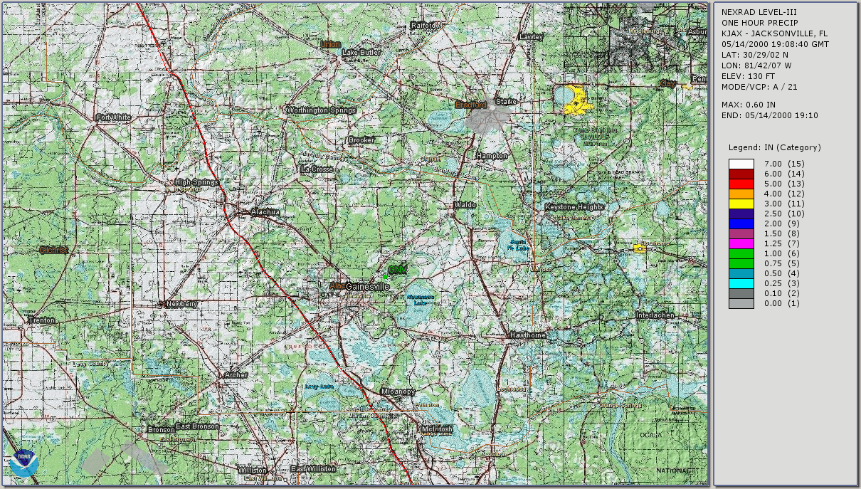
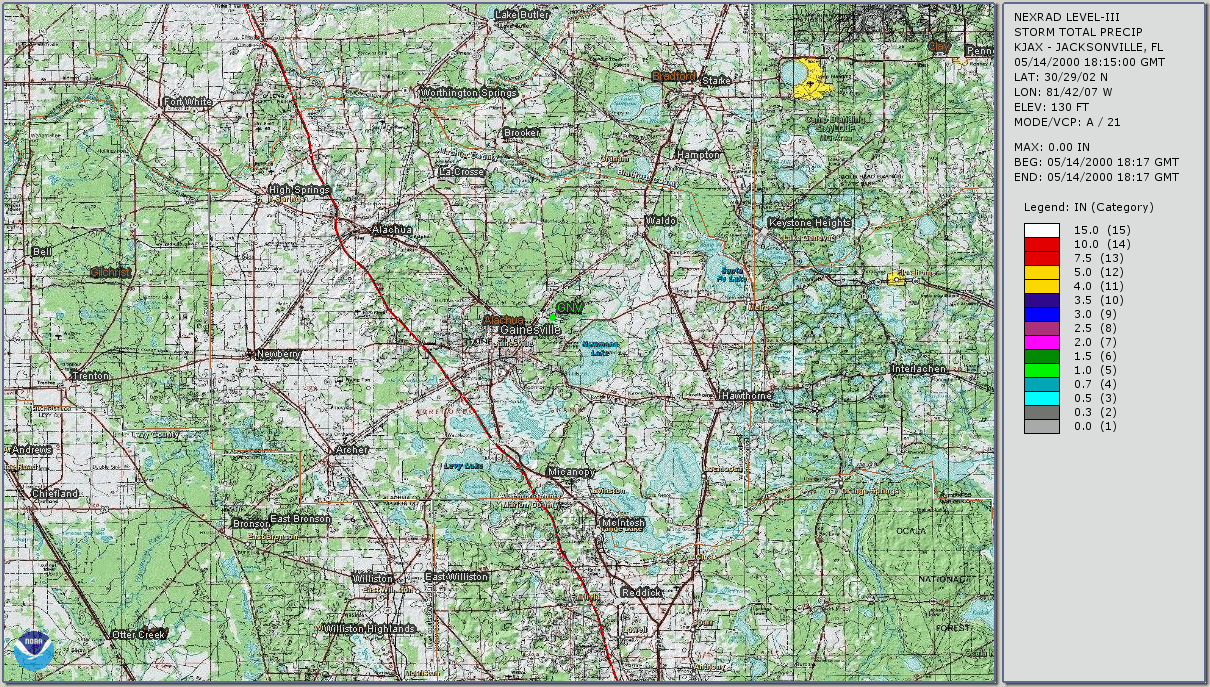
The thin track that the storm made across the county was also interesting.
This was visible in the later precip. amounts radar display.
After the storm passed, I could see some "mammatus" (pouches) on the
underside of the anvil, which is supposed to be indicative of strong
updrafts. These quickly dispappeared after a very short while - leaving
only barely perceptable up-and-down "striations" where the anvil connected
to the updraft tower. I took this to mean that the storm was finally losing
strength. I wish I'd taken an example photo of this, but I didn't have the
camera with me, then. I was driving to the store at the time.
At just before sunset, returning from the store, I looked eastwards
towards the storm now perhaps over Flagler county, still huge, and it had
a CE3K "mothership" type of appearance to it, made "CE3K orange" by the
low sun. I wish I could have taken a photo of that, too. ["CE3K" = Close
Encounters of the Third Kind, referring to the movie.]
I took this digital photo of some of the hail I
was able to gather. Of what I gathered I put it in the freezer for later
closer examination. Its a little whited-out by the flash, sorry about that,
but the sizes and shape-outlines are there. Anyway, I have some interesting
video and some digital photos which I showed at the May 15th ARES-RACES-SKYWARN
Communications meeting.
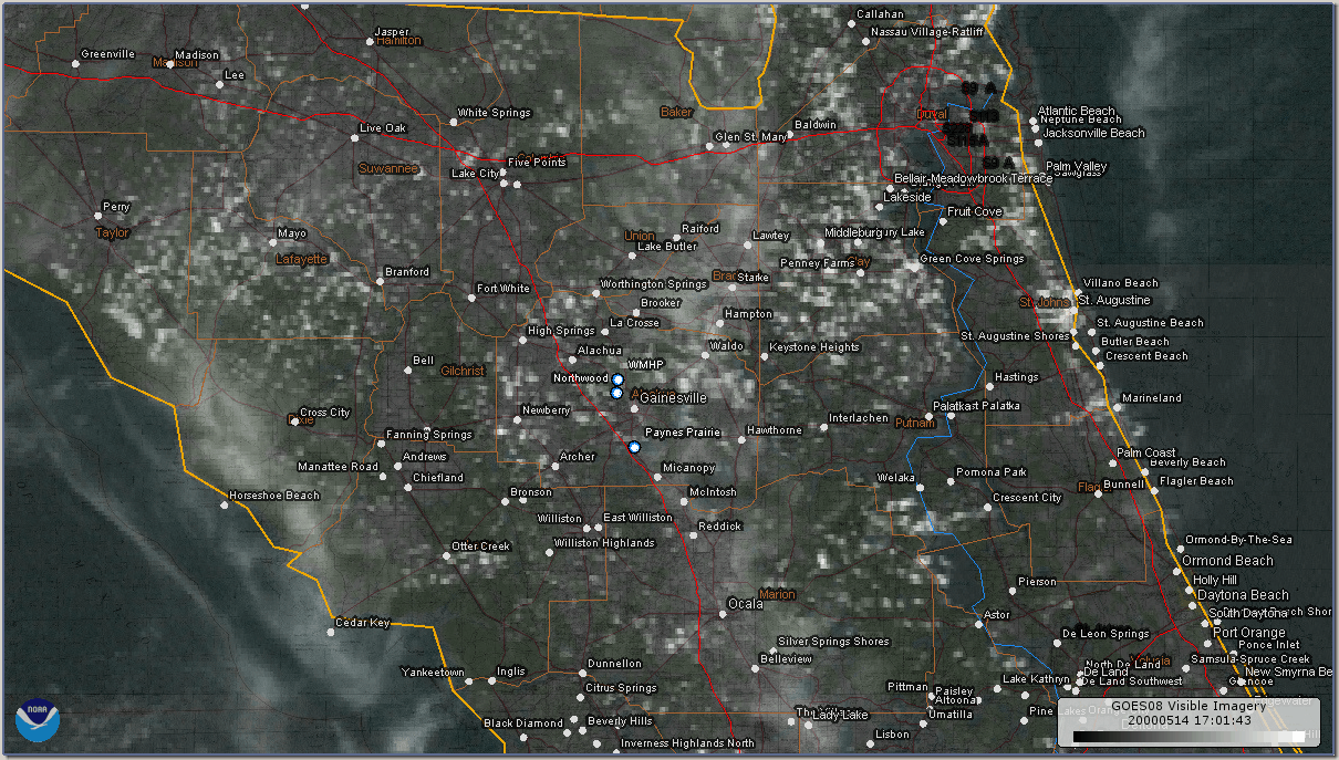
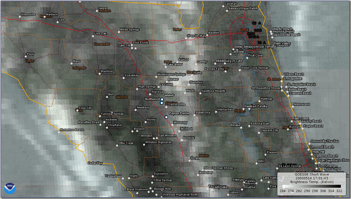
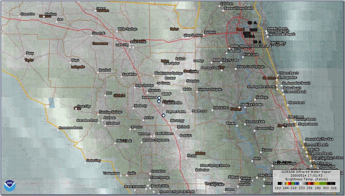
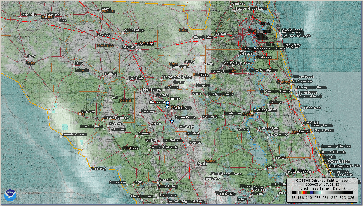
Satellite Imagery:
RADAR Imagery:
(For a quick general description of the various radar products and each of their uses, see NCDC Radar Products.)
Administrative 'Yet To Do':
- Obtain satellite imagery
- Obtain AFDs, ZFPs, HWOs, LSRs, and any severe-related watches/warnings
![[Alachua Co. SKYWARN Logo]](../images/logos/acskyw3d.jpg)


![Some spotting/chasing-related educational links]](../images/buttons/study1.gif)


![[ANIM: NOAA/NWS-JAX Wx Radio Page]](../images/logos/nwr.gif)
![[ICON: Alachua County FreeNet]](../images/logos/freenet.jpg)
![[ANIM: SKYWARN Pog]](../anim/skywbutn.gif)
![[ANIM: Vid-Cam]](../anim/mscamera.gif)
 [ Top of Page ]