Weather-related Videos

- Microburst Damage - Whitney MHP
Date: July 17, 1997 - 15:40 Hours ET
Location: Whitney MHP, Gainesville, FL
Camera Used: RCA CC-432 VHS vidcam
Camera Mode: Auto-focus/Auto-iris
05:21 [ 110 MB ] [ standard format ]Enroute to the Oaks Mall from Whitney MHP to pick up a friend, encountered a driving, windy, thunder-crashing rainstorm. After arriving back at Whitney MHP, noted wind-related damage all around the park, indicative of downburst winds. There were good-sized branches downed from trees all about the park, and in the back corner of the park, someone's carport rooftop looked somewhat smashed.
- Multi-cellular Cb Over Marion County
Date: July 23, 1997 - 19:46 Hours ET
Location: Near US-441 and NW 34th St, Gainesville, FL
Camera Used: RCA CC-432 VHS vidcam
Camera Mode: Auto-focus/Auto-iris
03:37 [ 106 MB ] [ standard format ]Large, training multi-cellular storms noted somewhere over Marion County. Viewed from the old Winn-Dixie plaza located in the area behind the FHP station on 441 and NW 34th, in Gainesville, FL.
- Lightning Damage To Tree - Whitney MHP
Date: January 24, 1999- 13:25 Hours ET
Location: Whitney MHP, Gainesville, FL
Camera Used: RCA CC-432 VHS vidcam
Camera Mode: Auto-iris/Auto-focus
13:16 [ 389 MB ] [ standard format ]I was at my desk in my bedroom during a thunderstorm with my window blinds closed when out of the corner of my eye, through cracks between the leaves of the blinds next to me I saw a VERY bright repeated flash, followed almost instantly by an extremely loud thundercrash. I ducked by instinct and then opened the blinds and sat back down and tried to remember where the flash had occured through the blinds to try to gauge where the stike had occured exactly. I was able to narrrow it down to a tree in a resident's yard one street down from me. After the storm was over, I went over to the resident's house and got permission to videotape the strike to the tree to document it for educational purposes.
- Hail Event - Whitney MHP
Date: May 14, 2000 - 1713 Hours ET
Location: Whitney MHP, Gainesville, FL
Camera Used: RCA CC-432 VHS vidcam
Camera Mode: Auto-focus/Auto-iris
06:51 [ 201 MB ] [ standard format ]Started out as a thunderstorm and turned into a pretty major hail event. Hail started at about a half-inch in size and slowly graduated to large balls that on occasion looked to be nearly 3-inches round. When the storm subsided, I ran outside as quickly as possible to gather as many varied pieces of hail before the rain-soaked pieces melted too much from their original sizes and shapes. The largest piece I was able to rescue was measured at about 2-1/2-inches.
- Waldo Wall Cloud? (Jim Carr / KC4MHH)
Date: July 16, 2000
Time: Approx. 3:40 PM ET
Location: Waldo, FL
Camera Used: Canon Ultura digital vidcam (dash-mounted)
Camera Mode: Auto-focus/auto-iris
19:33 [ 225 MB ] [ standard format ] [ WITH CAPTIONS ]Video of a possible wall cloud passing over the city of Waldo, Florida. (We're not really sure what it is...some area of inflow for sure.) There were warnings issued for that area at tha time. After watching the cloud, the driver went south after passage of the event and then headed back north, immediately. As he did so, he ran into heavy rains and VERY strong winds which pushed his van around a bit, forcing him to pull off. I'm hoping he didn't actually end up accidentally "core punching", but if a wall cloud, then what was experienced could seem to support that. Unfortunately the spotter didn't remember to turn on his date/time stamp, OR to call in what he was seeing to the NWS. (Which means that as a result nothing was published in the Local Storm Report for the day.) So, unfortunately there is no record of it, EXCEPT in this video.
Note the gas prices at the time of the video: $1.58/gal. (Where are those prices, today?)
As the driver first pulls into Waldo, we get a brief chance to see a wider area of the sky, but there's a lot of whiteout/oversaturation so it's hard to tell what we're looking at in the surrounding sky. The area of inflow looks like it might be attached to something larger and taller.
In various places in the video, another ham operator on the radio is making mention of a thunderstorm warning being issued in the area. At another point the ham stated that the warning issued ten minutes previously had advised that the storm would be in the vicinity of Waldo "in the next ten minutes". Later in the video a dispatcher can be heard on the fire/rescue radio also repeating the severe thunderstorm warning (much later than it had been for some reason) "until 4:15 PM", and that "the severe thunderstorm will be near Waldo by 3:50", which would put the time slot sometime around or before 3:40pm in the day, would be my best evidence-garnered guess. So it would appear that the situation setup would seem to be possible.
The following related data is from the Iowa Environmental Mesonet (IEM) archives:
Below are related images of the day garnered from ?:
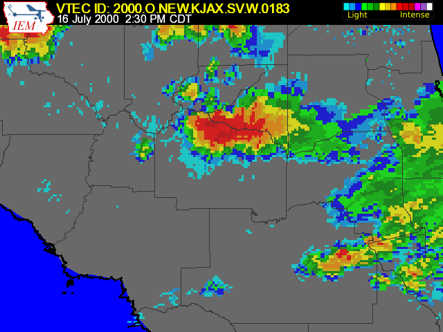
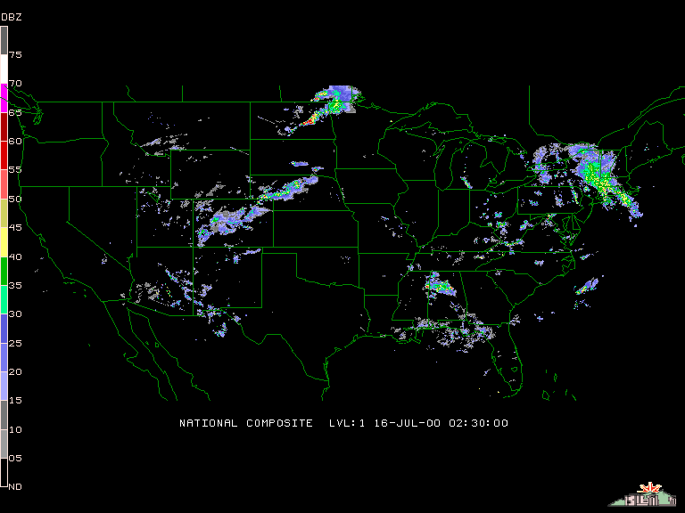
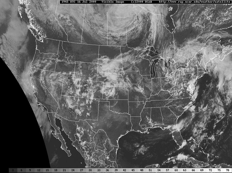
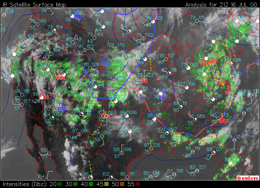
- National RADAR - 07/16/2000 (entire day, animated GIF, low res)
- National Satellite Image - 07/16/2000, 1945 HRS UTC
- National Satellite/RADAR Composite Map
If an actual wall cloud, this could be the only known footage of one occurring in Alachua County.
UPDATE - 05/30/2011: I did have Chuck Doswell take a look at it and he advised "It looks like a true, rotating wall cloud to me, but it dissapates quickly, likely being undercut by outflow."
- Waldo Wall Cloud Event (Jim Carr / KC4MHH)
Date: July 16, 2000
Time: Approx. 3:40 PM ET
Location: Waldo, FL
Camera Used: Canon Ultura digital vidcam (dash-mounted)
Camera Mode: Auto-focus/auto-iris
06:19 [ 66 MB ] [ standard format ]Same as above. Smaller-sized MPEG file. Only contains the section where Jim is sitting in the gas station. No subtitling added.
- Waldo Wall Cloud Event - Time Lapse (x15) (Jim Carr / KC4MHH)
Date: July 16, 2000
Time: Approx. 3:40 PM ET
Location: Waldo, FL
Camera Used: Canon Ultura digital vidcam (dash-mounted)
Camera Mode: Auto-focus/auto-iris
01:23 [ 46 MB ] [ standard format ]Time-lapse video of the Waldo Wall Cloud. (x15) You can see the cloud motion going on here much better because it's sped up.
- Turbulent Skies - Whitney MHP (You Tube version)
Date: July 16, 2000 - 1801 Hours ET
Location: Whitney MHP, Gainesville, FL
Camera Used: RCS CC-432 VHS vidcam
Camera Mode: Auto-iris/Auto-focus
04:22 [ 31 MB ] [ standard format ]The underside of a particularly turbulent-looking gust front from an approaching thunderstorm. Lots of neat-looking cloud movement going on which fascinated me.
- Downburst & Damage - Whitney MHP
Date: July 20, 2000 - 1635 Hours ET
Location: Whitney MHP, Gainesville, FL
Camera Used: RCA CC-432 VHS Vidcam
Camera Mode: Auto-iris/Auto-focus
11:57 [ 350 MB ] [ standard format ]This started out as one of those distant "war-zone" thunderstorms. I love those kinds of thunderstorms. They're so cool to listen to. The storm got closer and closer until eventually something passed over my home and for a few seconds the wind and rain got so bad there was a near white-out situation. After the storm was over and I inspected things outside, I discovered that the skirting underneath my mobile home had been blown out, along with some insulation in one place. As well, my neighbors large oak tree had a large branch that had been twisted upwards and back over it self, leaving it broken and dangling. I'm not sure what happened exactly. I'm more inclined to believe that this was a sudden microburst event rather than a tornado. Most of the blown out skirting originated in the close space between my mobile home and the storage shed parked perhaps 1 foot away from teh side of the home. The winds must have come striaght DOWNWARDS and had no where to go. The skirting in the space between the home and the shed was pushed inwards, whilt the rest of the nearby skirting had been pushed outwards. So yah, I'm pretty sure that what happened here came from straight up and was pushing downwards, rather than anything coming from the side or from random directions.
- 'Storm Spotters' - WUFT/TV-5 (Aired May 31, 2002)
Air Date: May 31, 2002
Channel: WUFT/TV, Cox Channel 5
03:07 [ 91 MB ] [ standard format ]WUFT/TV-5 came to interview us during a spotter training class in 2002. Portions of video from the May 14 hail event and the July 16 downburst (both above) event were used in the story.
- Squall Line Greenage (Jim Carr / KC4MHH)
Date: Mid-2004 (Exact date/time not known)
Location: Vicinity of Haile, FL (NW of Gainesville)
Camera Used: Canon Ultura digital vidcam (dash-mounted)
Camera Mode: Auto-focus/auto-iris
02:26 [ 72 MB ] [ standard format ]Video of a cool, mean-looking approaching squall line that was very windy and showed some very obvious green - sometimes indicative of hail. Unknown date and time. Courtesy Jim Carr / KC4MHH.
- Multi-cellular Thunderstorm & Gust Front - Archer Rd Wal-Mart
Date: July 06, 2008 - 1844 Hours ET
Location: Wal-Mart, SW Archer Road, Gainesville, FL
Camer Used: Canon HV-20 HD vidcam
Camera Mode: Portrait
Lens Used: Raynox wide-angle lens
16:10 [ 474 MB ] [ widescreen format ]While in front of the Wal-Mart on Archer Road in Gainesville, FL, I took time out to video a large thunderstorm to the southwest. I used a Raynoc wide-angle lens and I'm definitely NOT happy with it. You can see why in this video. You have the "binocular" shadow (the effect is actually called vignetting), and there is pretty bad lens aberration (called in lens parlance chromatic aberration). But I wanted the wide-angle shots. Later in the video I recorded an approaching gust front from the storm.
- NASA Saving Lives - Science Daily
Air Date: September 01, 2008
Channel: NPR (syndicated on other nationwide TV news shows, too)
01:57 [ ? MB ] [ standard format ]Earth Scientists And Meteorologists Create Historically-Based, Realistic Weather Animations
42-seconds of the episode is an NPR interview segment with me which includes video shorts from the May 14, 2000 hail event, the July 17, 2000 microburst event, and the July 6, 2008 gust front event.- War-zone Thunderstorm
Date: January 21, 2010 - 1303 Hours EST
Location: NW Gainesville
Camera Used: Canon HV-20 HD vidcam
Camera Mode: Portrait, Manual-Focus
10:34 [ 305 MB ] [ widescreen format ]January 21, 2010 - 01:03 PM. When storms have nearly non-stop thunder and lightning they often sound something like a 'war-zone'. Thus, I like to call them 'war-zone' thunderstorms. It occurs when lightning strikes occur so often - many times a second - that the sound of the thunder crashes don't have a chance to completely abate before another thunder crash occurs on top of or right on the heels of other thunder crashes. The thunder crashes can often sound like train wrecks, or like a bowling alley, or...like bombs being dropped all around you. This is ten minutes worth of video that I shot mostly for the sounds, and not so much for the show. Start this video going and turn the volume up on your good stereo speakers and just sit back and close your eyes.
- War-zone Thunderstorm (YouTube Version)
10:34 [ 67 MB ] [ You Tube version / widescreen format ](Same as above. Smaller file size. Audio is about half, though; so you won't get the full audio experience as in the larger version.)
- Marion County Thunderstorm
Date: April 26, 2011 - 1937 Hours ET
Location: Lowes, NW 13th St, Gainesville, FL
Camer Used: Canon HV-20 HD vidcam
Camera Mode: Portrait, Sunset
Lens Used: Raynox wide-angle lens
1:53 [ 126 MB, Quicktime movie ] [ widescreen format ]Large training thunderstorm, I believe along a seabreeze front in Marion County.
- Anvil Underside
Date: April 28, 2011 - 1541 Hours ET
Location: NW Gainesville, FL
Camer Used: Canon HV-20 HD vidcam
Camera Mode: Portrait
Lens Used: Raynox wide-angle lens
1:59 [ 59 MB, Quicktime movie ] [ widescreen format ]This is a time-lapse movie of the underside of a huge thunderstorm anvil slowly crossing over Gainesville on the afternoon of April 28, 2011. To the eye, anvils just seem to sort of sit in one place, looming over entire towns. But if you could speed up time, you'd see how they actually move.
The actual video is about 28 minutes long. It has been sped up by 2000% by the video editing software so that the time lapsed is just 1 minute and 30 seconds. The video was taken from my front lawn.
There are three viewing angles involved. The first one starts off looking to the south. This cuts to a view to the northwest above the rooftop of my home. The third cut is looking to the southwest.
This is my first experimentation with time lapse photography. In the future I hope to get some shots of thunderstorm formation, and some night-time video of storms and stuff.
- Fair Weather Cumulus Burn-off
Date: May 12, 2011 - 1600 Hours ET
Location: NW Gainesville, FL
Camer Used: Canon HV-20 HD vidcam
Camera Mode: Portrait
Lens Used: Raynox wide-angle lens
1:34 [ 34 MB, Quicktime movie ] [ widescreen format ]This is a time-lapse movie of some simple fair weather cumulus lazilly moving northwest to southeast across the sky, while being burned away by the bright sun. Kinda looked like suds on the roof. Less special effects, the actual video is only about a minute long. I was anxious to do something wih the camera. :)
The time compression is 2000%, x20, or 20 minutes compressed into 1.
- Thunderstorms
Date: May 14, 2011 - 1104 Hours ET
Location: NW Gainesville, FL
Camer Used: Canon HV-20 HD vidcam
Camera Mode: Portrait
Lens Used: Raynox wide-angle lens
1:52 [ 117 MB, Quicktime movie ] [ widescreen format ]This is a time-lapse movie of some scenes from today's thunderstorms. First scene is part of an anvil from the passing frontal storms from my front yard looking south. Second scene is of the pouring rains and strong winds which eventually fade to calm taken from my front porch looking north. The third scene is taken from my back yard looking north, showing the passage of accessory cloudage after the passage of the frontal storms.
The time compression is 2000%, or x20.
- Post-Front Passage
Date: May 14, 2011 - 1758 Hours ET
Location: Alachua, FL
Camer Used: Canon HV-20 HD vidcam
Camera Mode: Portrait
Lens Used: Raynox super wide-angle lens 0.5x
1:28 [ 34 MB, Quicktime movie ] [ widescreen format ]This is a time-lapse movie of the sky at 1800 hours on the same day, after the front had passed through Alachua County into Marion County.
The time compression is 2000%, or x20.
- Downed Tree - June 06, 2011
Date: June 06, 2011 - Approx. 1800 Hours ET
Viewing Location: NW Gainesville, FL
Camer Used: Canon HV-20 HD vidcam
Camera Mode: Portrait
Lens Used: Standard lens and Raynox super wide-angle lens 0.5x
2:32 [ 69 MB ] [ widescreen format ]Tree downed across the street. Tree was approx. 1 foot in width at the base and exhibited some additional damage in the form of holes bored by insects which obviously contributed. This obviously wasn't a HUGE tree but similar damage was occuring in various places around the county. Lots of storms today popping up all over. The rain is louder in the Florida Room because of the metal roof. (I like sitting in this room during light rains because of the sound.
Some additional related still photos:
Video starts out showing some quick shots of the rain that occurred at around 3:30pm. Note that at the end of the rain shots is a shot of the house across the street (on the left), showing that the tree was still standing at 3:41pm. Later on in the early evening I began to hear chain saws outside and poked my head out and noticed the tree down across the street, and crews working on another home down the street. When asked if a tree had fallen, a tree cutting employee advised that there was no tree down, that a branch that had fallen upon the roof of the home down the street was being removed and other limbs cut. I'm not able to advise on how strong the wind gusts were which brought this tree down. As well, it would be difficult to estimate because of the insect damage which obviously had compromised the tree trunk at the base and obviously had some contribution. I guess what I'm saying is that the tree was downed not solely by the brute strength of the wind gusts but obviously by a combination of the wind and the insect-weakened trunk.
- Gust Front Passage Over Lowes - July 26, 2011
Date: July 26, 2011 - 1323-1343 Hours ET
Viewing Location: Lowes Home Improvement, NW 13th St, Gainesville, FL
Camer Used: Canon HV-20 HD vidcam
Camera Mode: Manual Iris
Lens Used: Raynox super wide-angle teleconverter lens 0.5x
01:20 [ 84 MB ] [ widescreen format ]
ALTERNATE: [ YouTube ]While making a deposit at the bank, I noticed this gust front quickly making it's way across NW 13th Street. I raced over to the Lowes parking lot and set up and took this video of the front as it passed overhead.
The first shot is looking NE over the Bank of America on NW 13th Street. Subsequent shots were taking looking back over Lowes, itself, more towards the SW.
This stuff, to me, is so fascinating to watch, especially in time lapse. It's like watching some sort of an upside-down ocean wave breaking across the surface of some invisible "beach" layer in the atmosphere. Looks almost the same to me. ...And look at how fast it moves, too! Then it slowly loses energy and just sortuh falls apart, breaking up in the end.
The actual time span of the event as filmed is twenty minutes. Once home, I created this compressed time lapse video, which covers the whole event in one minute.
Time compression is 2000%, 0r 20x.
- Lightning Damage To Tree - Whitney MHP
[ Top of Page] [ Main Home Page]
Todd Sherman's Weather-related Videos
Todd L. Sherman/KB4MHH
Gainesville, Alachua Co., Fla.
E-mail: wxvideos@alachuaskywarn.org
Page Created: January 22, 2010.
Last updated: July 26, 2011.
Copyright (C) 2010-2011 by Todd L. Sherman / KB4MHH.
All Rights Reserved.