Scud Funnel Cloud - July 31, 2009
Date/Time: July 31, 2009 - Between 12:45-12:48 PM EDT
Location: I-75, near Paynes Prairie, Gainesville, FL
Submitted By: Jim Saunders
![[ Funnel Cloud Look-a-like ]](http://www.fireline.org/skywarn/scudfunnel/2009MinnSummer266-5pct.jpg)
![[ Funnel Cloud Look-a-like ]](http://www.fireline.org/skywarn/scudfunnel/2009MinnSummer267-5pct.jpg)
![[ Funnel Cloud Look-a-like ]](http://www.fireline.org/skywarn/scudfunnel/2009MinnSummer268-5pct.jpg)
![[ Funnel Cloud Look-a-like ]](http://www.fireline.org/skywarn/scudfunnel/2009MinnSummer269-5pct.jpg)
![[ Funnel Cloud Look-a-like ]](http://www.fireline.org/skywarn/scudfunnel/2009MinnSummer270-5pct.jpg)
![[ Funnel Cloud Look-a-like ]](http://www.fireline.org/skywarn/scudfunnel/2009MinnSummer271-5pct.jpg)
![[ Funnel Cloud Look-a-like ]](http://www.fireline.org/skywarn/scudfunnel/2009MinnSummer272-5pct.jpg)
![[ Funnel Cloud Look-a-like ]](http://www.fireline.org/skywarn/scudfunnel/2009MinnSummer273-5pct.jpg)
Jim Saunders caught this series of photos of something that appeared to be a
"funnel cloud" somewhere near Paynes Prairie in Gainesville while driving along
I-75. Jim describes the situation:
"We were driving from Stuart to Gainesville, Florida. We had passed the
exit to Micanopy. It was not raining, although we felt gusty winds as we
drove. The cars coming from the other direction had their lights on, so I
assume they were coming out of rain, and you can see rain in the pictures. We
did drive into rain, and that is when we lost sight of the funnel cloud. The
funnel cloud was just to the West of I-75. Perhaps the area is a preserve,
Paynes Prairie? I took the pictures between 12:45 and 12:48 P.M."
We really cannot tell what this is based upon the photographs. Can't quite
discern any real "tube". No discernable rotation noted. There doesn't appear
to be any debris cloud. The wide shot doesn't seem to show any wall cloud.
This one had me kinda stumped, so I called in for some help from some people
with some good experience -
Charles Doswell,
Tim Samaras,
Sam Barricklow,
Gilbert Sebenste,
and Roger Edwards,
Charles Doswell: "Looks like scud to me ... but stills just don't work very
well in cases like this, so I can't be absolutely certain."
Tim Samaras: "Hi Todd, Looks like scud to me--it would be great to see some
video of this feature--then one can tell for sure."
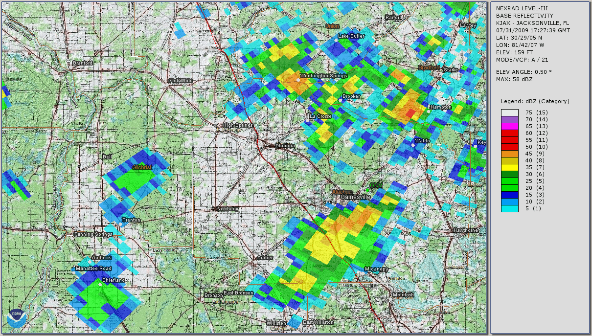
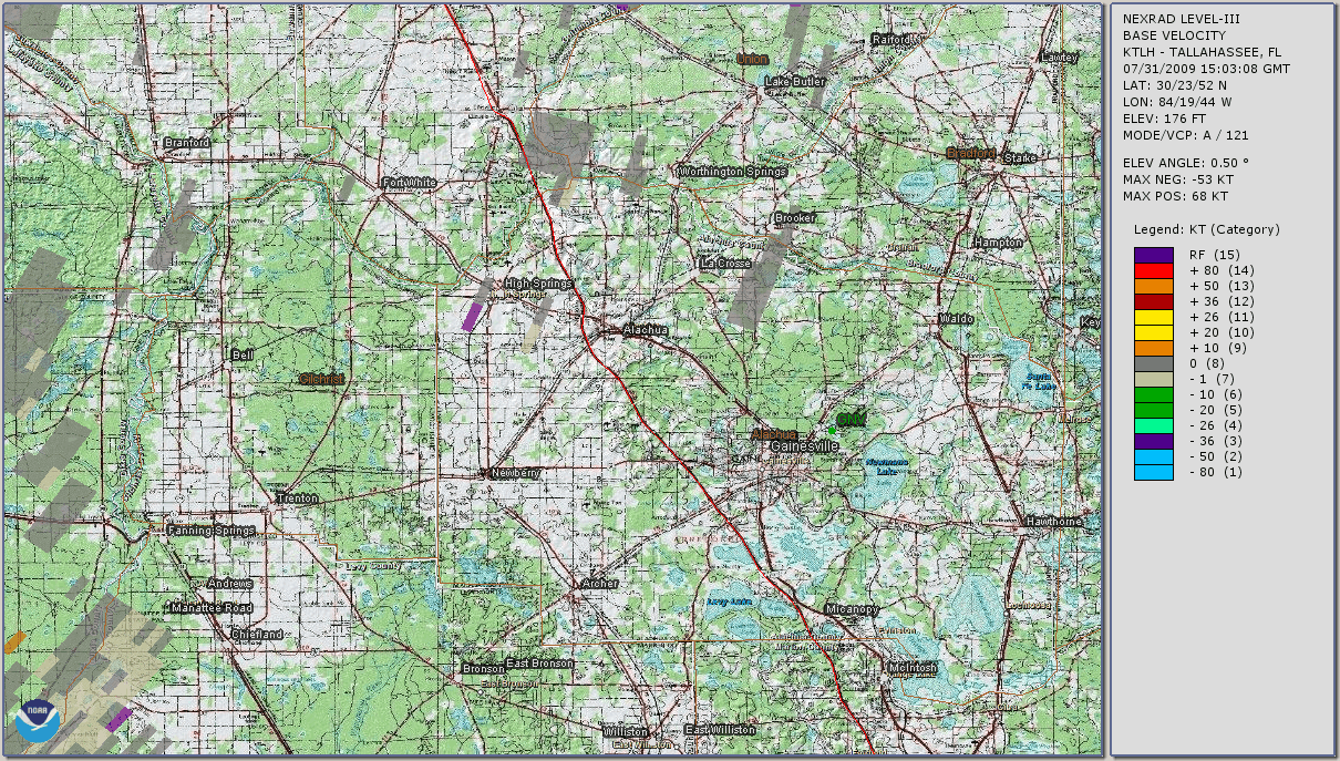
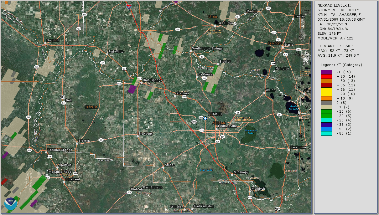
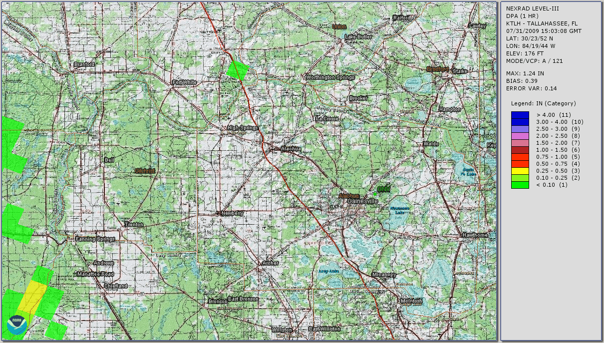
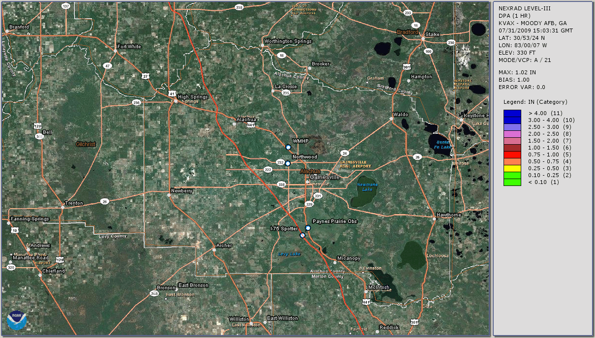
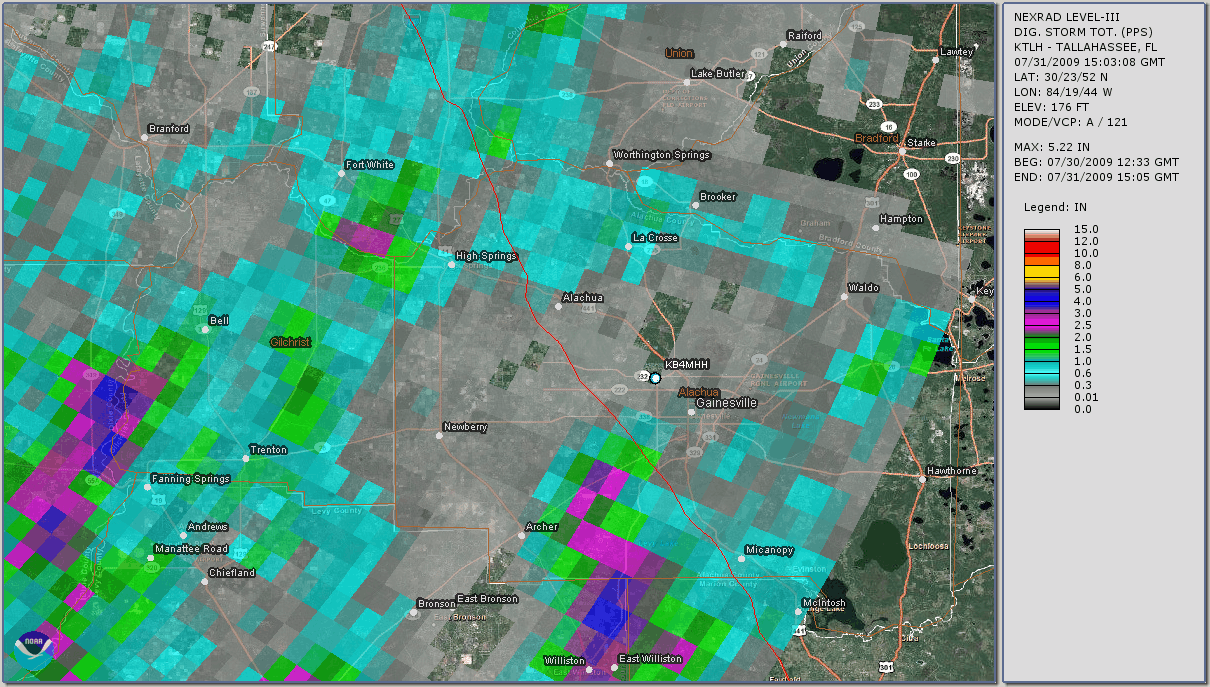
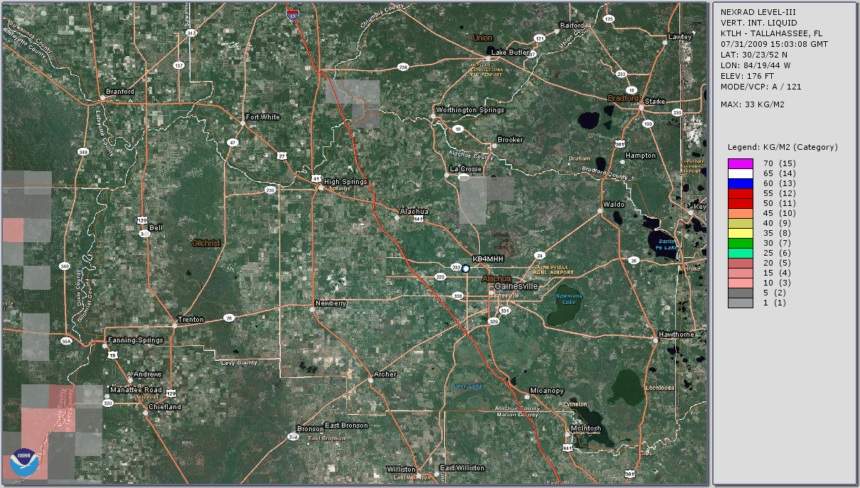
Sam Barricklow: "This is a tough one without seeing the motions involved.
Too bad he wasn't shooting video. It does appear to be non-rotating scud from
the still images. A close-in radar image, with reflectivity and velocity
display might be helpful. Roger Edwards at the SPC is interested in tornado
look-alike images, and might be able to provide additional information, radar
images and analysis."
Gilbert Sebenste: "Wow, that's a good one. I would say that this is a great
example of scud. Video is really needed here to be absolutely conclusive. But
the wider picture shows the establishing storm shot, and it's in an area where
you'd expect scud. I say that's what it is."
Finally, long-time chaser Roger Edwards added: "It could be an outstanding
non-tornado example for spotter training if you can verify that this feature
was not rotating. Was it? If not, it's just a scuddy chunk of cloud material
rising from on or near the ground, probably on the leading edge of a
storm-scale cold pool. It certainly has that appearance, based on my
experience."
As Charles, Tim and Sam all pointed out, if we had some video we could
see the dynamics of the cloud better, and perhaps the background clouds, and be
able to get a better idea.
Jim later said that he thought he did see some rotation in the scud,
but then added that the funnel originated from a place in the clouds which was
"higher than the rest of the surrounding clouds." If a real "funnel",
it should be pendant from a wall cloud lowering of the cloud base, not
from an area higher than the surrounding clouds.
So for now, we'll call this one "scud", which happens to be pendant low to the
ground, and which looks akin to a funnel cloud. It is quite a
fantastic-looking piece of scud, however. Quite photogenic. This one makes an
excellent and perfect example of how scud can trick you.
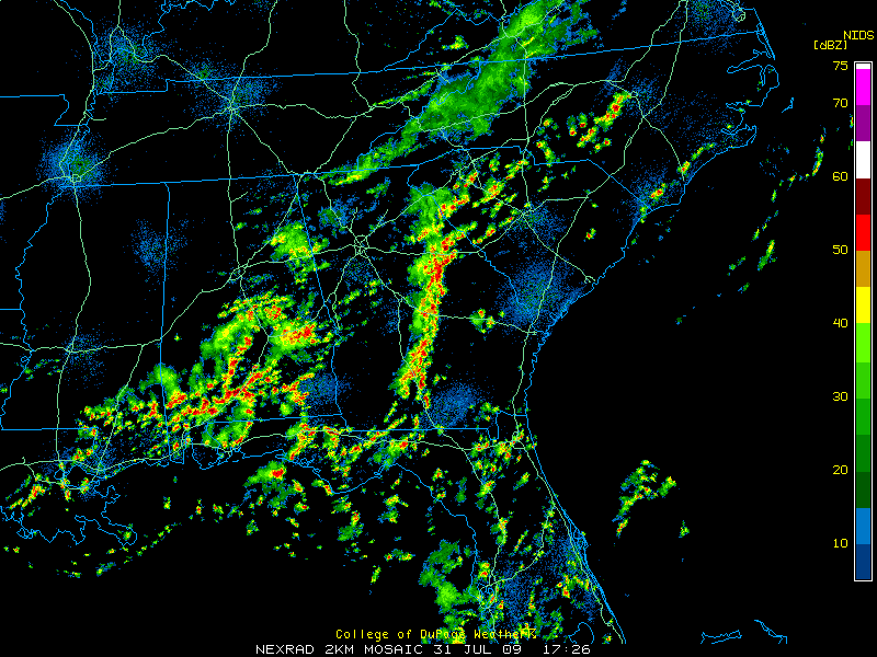
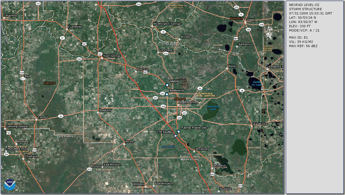
Satellite Imagery:
RADAR Imagery:
NOTE: KJAX (Jacksonville) was down for 6 hours this day, for a period which included the time within which the scud funnel appeared. Therefore, KTAE (Tallahassee) and KVAX (Moody AFB, GA) radar data had to be used in its place. (See here for surrounding area radar coverage maps.)
(For a quick general description of the various radar products and each of their uses, see NCDC Radar Products.)
Administrative 'Things To Do':
- Obtain AFDs, ZFPs, HWOs, and any LSRs for the day
- Check newspapers for any severe happenings for the day
![[Alachua Co. SKYWARN Logo]](../images/logos/acskyw3d.jpg)


![Some spotting/chasing-related educational links]](../images/buttons/study1.gif)


![[ANIM: NOAA/NWS-JAX Wx Radio Page]](../images/logos/nwr.gif)
![[ICON: Alachua County FreeNet]](../images/logos/freenet.jpg)
![[ANIM: SKYWARN Pog]](../anim/skywbutn.gif)
![[ANIM: Vid-Cam]](../anim/mscamera.gif)
![[ Funnel Cloud Look-a-like ]](http://www.fireline.org/skywarn/scudfunnel/2009MinnSummer266.jpg)
![[ Funnel Cloud Look-a-like ]](http://www.fireline.org/skywarn/scudfunnel/2009MinnSummer267.jpg)
![[ Funnel Cloud Look-a-like ]](http://www.fireline.org/skywarn/scudfunnel/2009MinnSummer268.jpg)
![[ Funnel Cloud Look-a-like ]](http://www.fireline.org/skywarn/scudfunnel/2009MinnSummer269.jpg)
![[ Funnel Cloud Look-a-like ]](http://www.fireline.org/skywarn/scudfunnel/2009MinnSummer270.jpg)
![[ Funnel Cloud Look-a-like ]](http://www.fireline.org/skywarn/scudfunnel/2009MinnSummer271.jpg)
![[ Funnel Cloud Look-a-like ]](http://www.fireline.org/skywarn/scudfunnel/2009MinnSummer272.jpg)
![[ Funnel Cloud Look-a-like ]](http://www.fireline.org/skywarn/scudfunnel/2009MinnSummer273.jpg)
 [ Top of Page ]